Bandwar Village Archive

Burhi Gandak River: Bandwar's Lifeline and Adversary

The river that named the village — flowing along the western edge of Bandwar
Updated on 2026-09-27
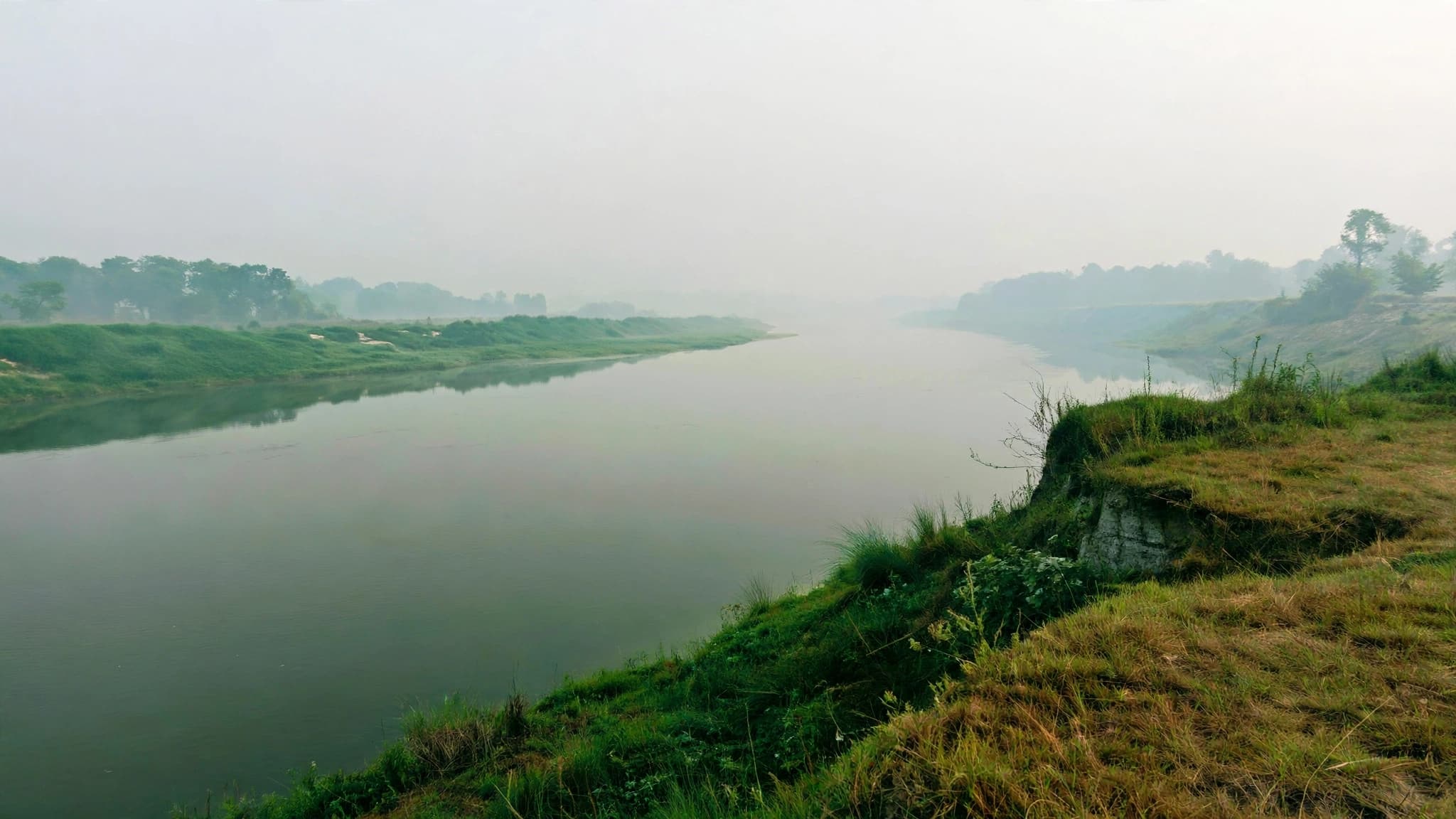
The Burhi Gandak river at dawn seen from the bandh, Bandwar, Begusarai (2026)
View Full Size
Listen to this article

Narrated in English (Browser TTS)

The Burhi Gandak is a flood-prone river that flows along the western edge of Bandwar, in Begusarai district, Bihar. Situated in the fertile Indo-Gangetic plain, it is the largest tributary of the Ganga in the region. Its annual floods shaped the village's geography, its agriculture, and — most importantly — its name. The embankment built along the river, the [[bandh-embankment-bandwar|bandh]], is widely believed to be the source of the village's name: Bandwar.

Origin of the Name

The name 'Burhi Gandak' means 'old Gandak'. The river is believed to be an old channel of the Gandak, which shifted course over centuries. As the Gandak moved eastward, it left behind this channel — older, slower, and shallower — which continues to flow through the plains of North Bihar. It is the largest tributary of the Ganga in the region, draining a basin that includes parts of Nepal's Terai and much of the Gandak's former floodplain. In the local imagination, the Burhi Gandak is not a minor stream but a river in its own right — a mother river that both feeds and threatens the villages on its banks.

Course Through Bandwar

At Bandwar, the Burhi Gandak flows along the western edge of the village, situated in the vast Indo-Gangetic plain. Its course is slow and meandering — typical of rivers in this region — and its waters are muddy for most of the year. The river forms the natural boundary between Bandwar and the villages to its west, and its western bank is visible from the bandh that runs parallel to it. The Chhatauna Bridge — an important crossing point for villagers travelling to the north bank — spans the river a short distance downstream. In the dry season, the river narrows considerably, and parts of its bed are exposed — a landscape of sand, water, and small islands.

The Bandh (Levee)

Because the Burhi Gandak floods almost every year, villagers built an embankment — a bandh — parallel to the river to protect their homes. Historically, the devastating floods of 1953 and 1954 in Bihar prompted the construction of massive levees across the state, and the Bandwar bandh is part of this legacy. It is from this bandh that the village is believed to have taken its name: Bandwar. The embankment, raised earthen and reinforced over generations, redirects floodwaters and protects the village from the worst of the annual flooding. It is the single most important piece of infrastructure in Bandwar — the physical boundary between the village and the river that would otherwise consume it.

Flood Risk and Human Impact

The river is classified as highly flood-prone. The district administration's flood hazard maps place Begusarai in the high-risk category, and the Burhi Gandak is one of the principal reasons. The river's floods are the product of a combination of factors: heavy monsoon rainfall in its catchment, the flatness of the terrain, and the river's own tendency to shift course. The village has experienced flooding repeatedly over the decades, though the bandh has mitigated much of the damage. Even so, the flood season — typically from July to September — is a period of vigilance for Bandwar's residents. Families in low-lying parts of the village move their belongings to higher ground, and the bandh is watched through the night during peak flow. The September 2025 diarrhea outbreak — which claimed more than ten lives — was a direct consequence of the same water insecurity that the river's floods create.

Agriculture and Economy

The river is central to the agricultural life of Bandwar. Its floodwaters deposit silt across the fields during the monsoon, enriching the soil for the rabi crop that follows. According to the Census of India 2011, the village has 635 cultivators and 1,839 agricultural labourers — a total of 2,474 agricultural workers who rely directly on this land. The fields along the river's edge — locally known as the diara lands — are among the most fertile in the village, producing wheat, maize, and pulses. But the river is also an uncertain ally: in years of extreme flooding, the same waters that enrich the soil can destroy an entire season's crop. The river's fish — including rohu, catla, and small local species — provide an important source of protein for households along its banks.

The Landscape

At dawn and dusk, the river offers a striking view — its still waters, the green embankment, and the dense tree cover on the opposite bank. It has become a familiar landmark for anyone visiting Bandwar. The light at these hours transforms the river into something almost abstract: a wide, silver sheet, interrupted only by the silhouettes of trees and the occasional boat. Wildflowers grow along the bank in the cooler months, and local birds — including kingfishers and egrets — are a common sight. For photographers visiting the village, the Burhi Gandak at dawn is the defining image of Bandwar. It is also the setting for the village's Chhath Puja celebrations, when the entire village gathers on the bandh to offer prayers to Surya Dev.

Present Day

The Burhi Gandak continues to flow along Bandwar's western edge, and the bandh continues to hold it back. The river's role in the village's life has not diminished — if anything, it has grown more important as the region's climate becomes more erratic. The Jal Jeevan Mission water tower now stands near the river's edge, drawing on groundwater that is itself connected to the river's aquifer. The Chhath Puja celebrations continue to be held at the bandh each year, drawing the entire village together on the riverbank. And the name of the village — Bandwar — remains a permanent reminder that, in this part of Bihar, the river is not just a feature of the landscape. It is the landscape.

Frequently Asked Questions

Why is the river called 'Burhi Gandak'?
'Burhi Gandak' means 'old Gandak'. The river is believed to be an old channel of the Gandak river, which shifted course over centuries. As the Gandak moved eastward, it left behind this channel — older, slower, and shallower — which continues to flow through the plains of North Bihar as the Burhi Gandak.
Does the Burhi Gandak flood Bandwar?
Yes — the river is classified as highly flood-prone, and Bandwar has experienced flooding repeatedly. The embankment (bandh) built along the river has mitigated much of the damage, but the flood season remains a period of vigilance for the village.
How did the Burhi Gandak give Bandwar its name?
The most widely accepted theory is that 'Bandwar' derives from 'Bandh'. In the local dialect, a bandh-waar — a place protected by an embankment — would naturally have been shortened to 'Bandwar'. The bandh was built by the village community generations ago to keep the river from flooding the village.
Where does the Burhi Gandak originate?
The Burhi Gandak originates in the Someshwar Hills of Nepal, and flows south through West Champaran, Muzaffarpur, Samastipur, Begusarai, and Khagaria districts before joining the Ganga. Its total length is approximately 320 kilometres.
What is the Chhatauna Bridge?
Chhatauna Bridge is a bridge over the Burhi Gandak near Bandwar, connecting the village to the north bank of the river. It is an important crossing point for villagers who need to reach villages on the other side, though its approach road has deteriorated in recent years.
How many people in Bandwar depend on agriculture?
According to Census 2011, out of a total population of 12,943, there are 635 cultivators and 1,839 agricultural labourers in Bandwar. This makes agriculture the primary source of livelihood for the majority of the village.

Read Next

The Bandh: Bandwar's Historic Flood Protection Embankment

The bandh is the embankment built along the Burhi Gandak to protect Bandwar from floods. It is widely believed that the village takes its name from this very structure — 'Bandh' becoming 'Bandwar'. It runs parallel to the [[burhi-gandak-river-bandwar|Burhi Gandak]] along the western edge of the village, and is the single most important piece of infrastructure in Bandwar.

Chhath Puja in Bandwar: Celebrating Surya Dev at Burhi Gandak

Chhath Puja is the most significant festival in Bihar and the Mithila region, dedicated to Surya Dev (the Sun God) and Chhathi Maiya. In Bandwar, the festival is celebrated at the [[bandh-embankment-bandwar|bandh]] along the [[burhi-gandak-river-bandwar|Burhi Gandak]], with the entire village gathering on the riverbank. A large idol of Surya Dev, mounted on his chariot with seven horses, is set up at the bandh, and the village observes four days of rigorous fasting and Vedic rituals.

Jal Jeevan Mission Water Tower: Piped Water in Bandwar

A water tower built near Bandwar under the central government's Jal Jeevan Mission. It stands near the [[bandh-embankment-bandwar|bandh]] along the [[burhi-gandak-river-bandwar|Burhi Gandak]], drawing on the local groundwater. The tower is part of a massive effort to bring piped drinking water to households that previously relied entirely on hand-pumps and wells.

2025 Bandwar Diarrhea Outbreak: Water Crisis and Public Health Failure

In September 2025, a severe diarrhea outbreak in Bandwar village, Begusarai, claimed over 10 lives in 15 days. The crisis was concentrated in Wards 1 and 2 (Mahadalit basti) and exposed the village's lack of clean piped water and sanitation. A health camp at [[gps-bandwar-musahri-school|Musahri Tola]] treated 26 patients and surveyed 293 households, accelerating the demand for the [[jal-jeevan-mission-water-tower-bandwar|Jal Jeevan Mission]] pipeline network.

Shivala: The Historic Shiva Temple of Bandwar

Shivala is the village's Shiva temple, standing in the centre of Bandwar, Begusarai, Bihar. It is one of the village's eight temples and has served as a place of worship for generations. Built entirely by village residents, without any government support, it stands in a grove of trees near the [[historic-well-chaupal-bandwar|historic well]] that anchors the village centre.

Historic Well (Chaupal) of Bandwar: The Village Gathering Place

Bandwar's historic well has served as both a source of water and a gathering place — a chaupal — for generations. It was the subject of a feature in Prabhat Khabar in July 2026, which described it as 'still the centre of social dialogue and intellectual discussion in the village'. It sits near [[shivala-temple-bandwar|Shivala]] and the [[chandrashekhar-chowk-bandwar|Chandrashekhar Chowk]], and has been a centre of village life for as long as anyone remembers.

Something is incorrect?

If you have additional details, let us know.

Suggest an Edit
Last updated: 2026-09-27Source: Bandwar Village Archive